Research
Landscape response to the Yellowstone Hotspot
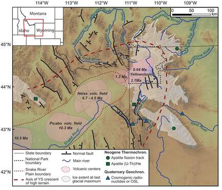 Overview of the history topography, and drainages surrounding Yellowstone. Modified from Bufe et al. (2014).
Yellowstone is an active example of mantle upwelling beneath the continental lithosphere. It has had profound impact on the topography of Oregon, Idaho, Wyoming, and Montana in its trek across the western US. Over the last ~16 Ma the motion of the Yellowstone hotspot shifted drainage divides and left the low-lying Snake River Plain in its wake. The currently active Yellowstone Plateau is surrounded by an arc of high topography, termed the Yellowstone Crescent of High Terrain. This project focuses on the geologic record of landscape response to uplift of present day Yellowstone across ka to Ma timescales with bedrock and detrital low T thermochronology, mapping and OSL dating of Gallatin River terraces, and numerical modeling. By tracking relief, erosion rates, and incision over multiple timescales, we can address questions such as: Did high topography precede the first volcanic eruptions associated with the Yellowstone Plateau? How do erosion rates and incisions track with magmatic activity?
This project was recently funded by NSF (2022-2024) in collaboration with Joel Pederson (Utah State University) and Marissa Tremblay (Purdue University).
Students: Chloë Weeks, Carlos Montejo
This project was recently funded by NSF (2022-2024) in collaboration with Joel Pederson (Utah State University) and Marissa Tremblay (Purdue University).
Students: Chloë Weeks, Carlos Montejo
Evolution of the western Snake River Plain
|
The Snake River Plain is a large arcuate topographic depression in southern Idaho. While the eastern portion of the Snake River Plain is a down warped lava plain formed in the wake of the Yellowstone system, the western Snake River Plain (WSRP) is a structurally controlled graben that once was an incipient continental rift. This WSRP rift basin hosts the deposits of paleo Lake Idaho which contain Idaho’s only petroleum producing basin, as well as valuable climatic records and groundwater resources for the rapidly growing Boise metro area. It is also adjacent to the Boise Mountains which some have argued show evidence for Miocene to recent uplift and incision. The WSRP is located in close proximity to both the Columbia River Flood Basalts (CRB) and the track of the Yellowstone hotspot (YHS) and both volcanic events have been proposed as driving mechanisms for the WSRP. This project aims to unravel the topographic history of the flanks of the WSRP - the Boise and Owyhee Moutntains - through a combination of apatite (U-Th)/He thermochronology and field mapping of volcanic surfaces. The topographic history can yield insight into the formation of the WSRP and how it relates to magmatic events and rift initiation in continental environments.
Students: Kelsey Wetzel (MSc 2020), Wenbo Zhan |
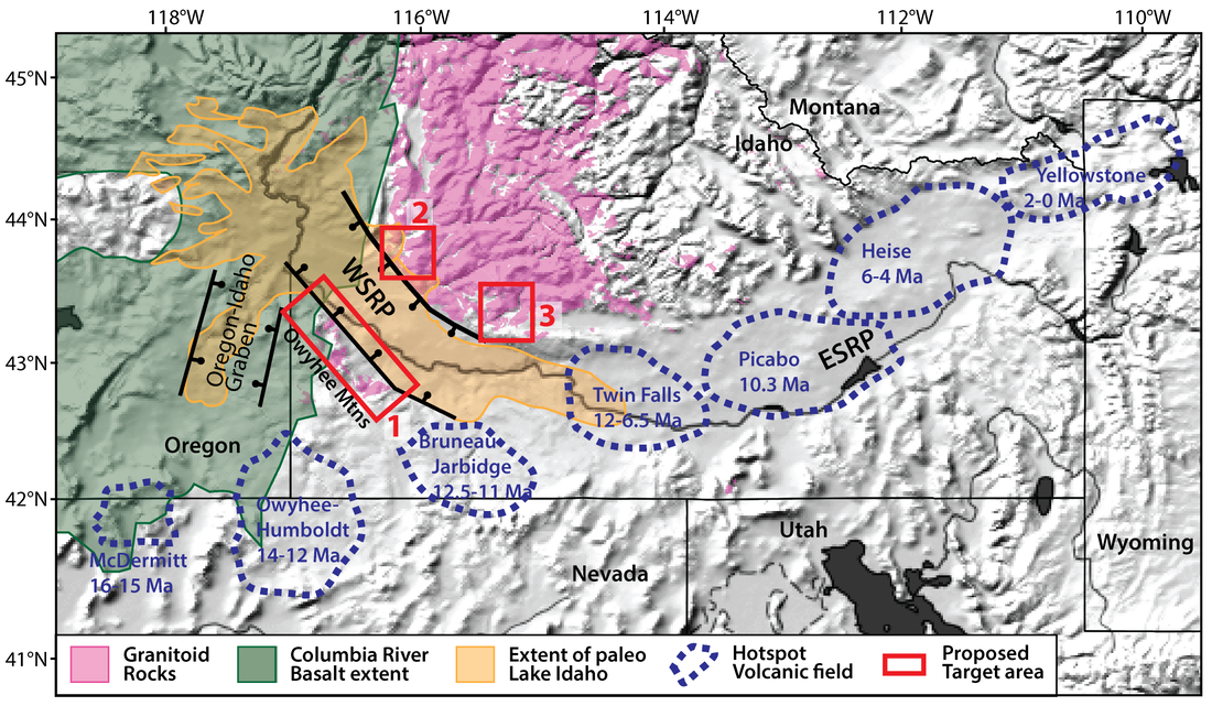
Shaded relief map showing the location of the WSRP and target areas for proposed work as well as CRB extent, YHS volcanic centers and ages, granitoid rocks, and extent of paleo Lake Idaho. After Camp & Ross (2004), Beranek et al. (2006), and Pierce & Morgan (1992).
|
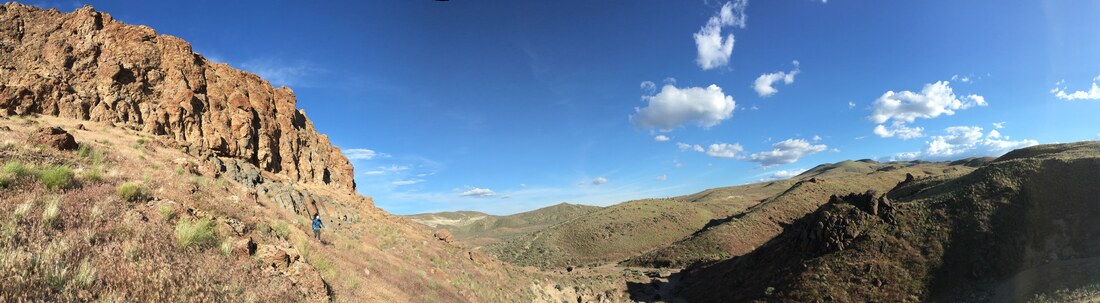
Kelsey hiking down after checking out a contact in the Owyhee Mountains, SW Idaho.
Uplift of the Southern African Plateau with landscape model inversions
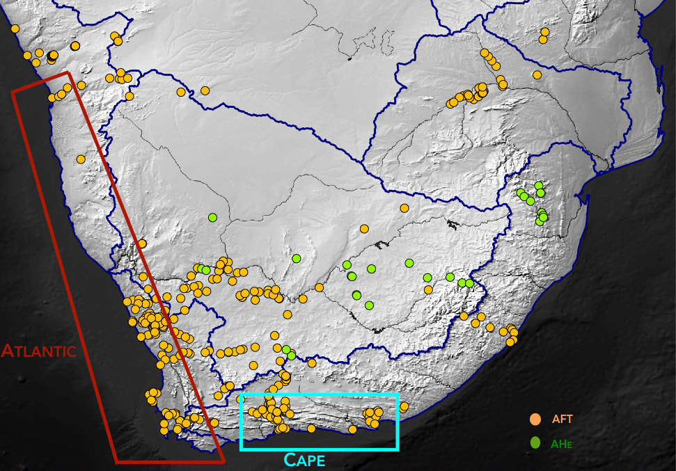
Shaded relief map of southern Africa showing locations of thermochronology dates and outlines of marine basins used to constrain the modeling
|
The origin of high topography in southern Africa has been the subject of debate for almost a century. Some argue that topography was formed in the Cretaceous due to deep mantle dynamics or lithospheric processes, with others arguing that it developed in the Cenozoic due to the East African Rift or seismic anomalies in the upper mantle. This project uses the large dataset of thermochronology dates now available across southern Africa, sediment flux volumes in the surrounding marine basins, and topographic metrics to test different hypotheses for uplift. We use a highly efficient landscape evolution model to run a large number of simulations with different parameters to constrain which geodynamic scenarios can reproduce the observed data.
Collaborators: Jean Braun (GFZ-Potsdam), Guillaume Baby, François Guillocheau, Cecile Robin (Université de Rennes 1), Rebecca Flowers (University of Colorado), Mark Wildman, Roderick Brown (University of Glasgow), Romain Beucher (University of Melbourne) |
Linking southern Africa's erosion history and mantle processes using kimberlites
|
The uplift of southern Africa is enigmatic, but most workers suggest that mantle processes are responsible for elevation gain. Because paleo-elevation is a difficult quantity to retreive from the geologic record, periods of erosion in southern Africa have often been taken to represent periods of topographic development. Here we use apatite (U-Th)/He thermochronology on kimberlites to detect erosion patterns across the interior of the southern African Plateau. Kimberlites are powerful geologic tools that record the state of the mantle and the sedimentary cover at the time of their eruption through their xenoliths. We harness this information to link patterns of erosion to patterns of mantle modification recorded in xenoliths. Using these patterns and other geologic information we can start to discern different types of mantle topography and surface response across regions of different lithospheric age. Collaborators: Rebecca Flowers (University of Colorado), David Bell (Nelson Mandela University) I blogged about my 2012 and 2013 field seasons here. Please have a look if you are interested in learning more about my fieldwork. |
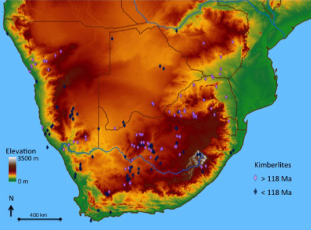
DEM showing the topography of southern Africa and the dated kimberlites (Jelsma et al., 2009). There has been quite a bit of apatite fission track thermochronometry around the edges of the plateau, but very little in the interior.
|
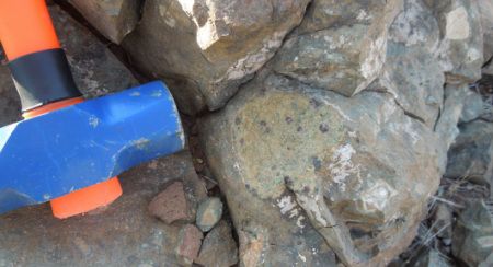
Garnet lherzolite xenolith from the Gibeon field, Namibia.
|
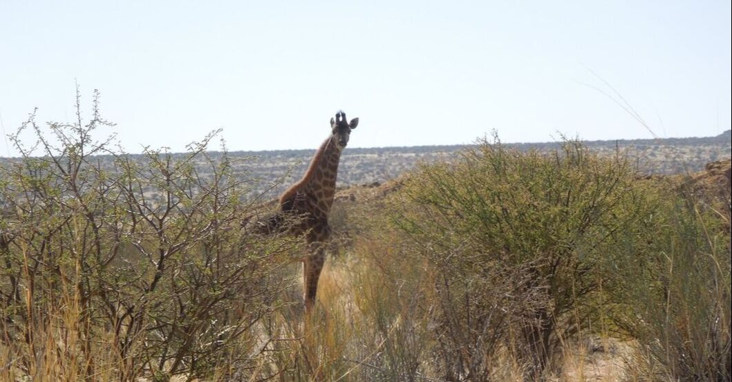
Found a giraffe while looking for a kimberlite! The plateau interior has regions of very low topographic relief despite its high elevations.
|
